This Geopark is a true natural laboratory for understanding the geological processes that have shaped our planet over the past 120 million years. The interaction between rock layers and marine action has produced a spectacular array of coastal features: cliffs, arches, islets, coves, beaches, tombolos, dunes, and estuaries. These outcrops reveal fossils of ancient tropical reefs, prehistoric beaches, and petrified ecosystems, bearing witness to events such as continental collisions, climatic changes, and biological extinctions.
The stretch between San Juan de la Canal and the Miengo Marsh is included in the Global Geosites Catalogue as one of the most significant geological sites in the world, under the designation “Liencres Dunes and Costa Quebrada Coastline.”
Discover the Global Geosite
–
Costa Quebrada not only displays, along a short stretch, an extraordinarily rich and attractive array of coastal landforms but also clearly demonstrates the processes shaping the coastline, allowing us to reconstruct its evolution over time.
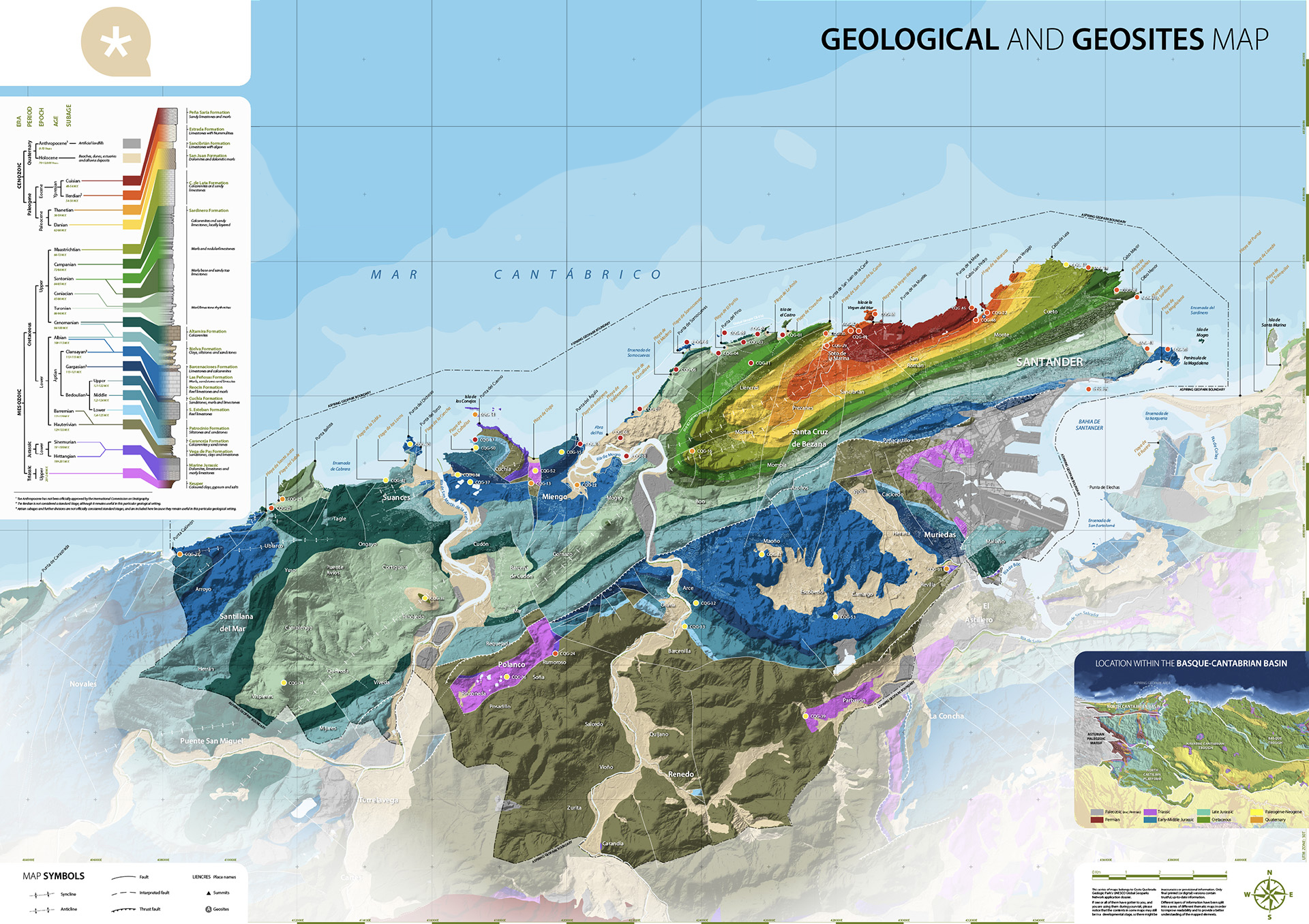
This Global Geosite is of primary geomorphological interest and is included in the inventory published by IGME under code Geosite CB010. It forms part of the International Relevance Geological Context (Law 42/2007): Coasts of the Iberian Peninsula. Its inclusion reflects its importance in illustrating the evolution of a retreating cliffed coast.
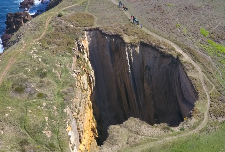
Socavón de Pedrondo
–
Immediately west of the La Arnía platform lies the Pedrondo Sinkhole, a relatively large collapse depression formed by undercutting. It covers 985 m², reaches a depth of 42 m, and has an excavated volume of approximately 18,000 m³. Its formation resulted from the opening of a passage through the Altamira Formation calcarenites at the base of the cliff by wave action. This passage was created by the fall of a series of blocks defined by the orthogonal network of joints characteristic of these Cenomanian materials. Wave action penetrates and erodes the Turonian marly materials previously shielded by the resistant limestone. About 50 metres west of the sinkhole lies the La Baselga Formation, which follows the same erosive pattern as the La Arnía platform.
Covachos
–
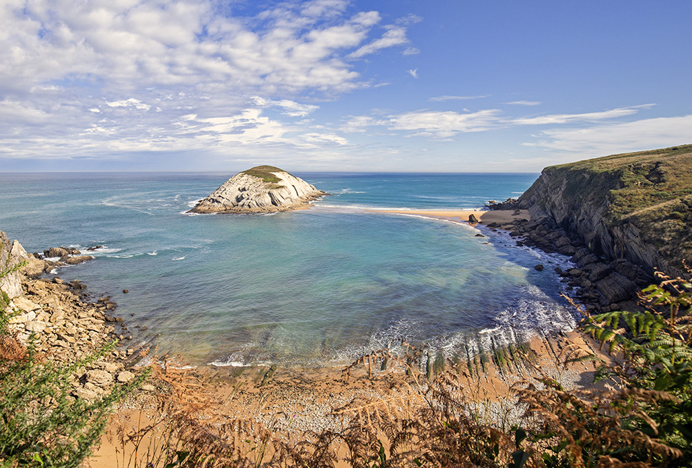
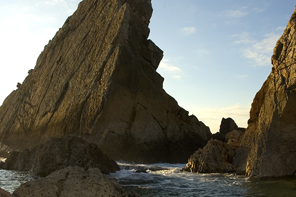
From east to west, the Covachos Formation is dominated by the El Castro Islet, created by wave-driven erosion of the surrounding area. In addition to the characteristic leafy appearance of the cliffs, composed of marl-limestone rhythmites with subvertical dips and featuring large slabs formed from the tops of the strata on the southern cliffs, the effects of coastal cliff retreat are evident in lithologies with dips favourable to the sliding of large slabs along bedding planes. The summit of the islet consists of residual relief, a remnant of the pre-existing landscape of gentle hills prior to marine action, where soils and vegetation remain preserved. The most remarkable features of this formation, however, are the depositional forms on the platform, particularly the tombolo connected to the islet.
La Arnía
–
Next is the geomorphological complex of La Arnía, a particularly rich assemblage of geomorphological features, along with stratigraphic and palaeontological elements. Broadly, it comprises a cove with a small beach at its base and an elliptical intertidal abrasion platform, separated by a residual relief of the former fluvial valley that ran parallel to the coast prior to coastal retreat. Resistant lithologies, formed by Cenomanian limestones, close the complex to the north, forming a row of needles and rock outcrops of varying sizes. The base of the beach is occupied by the El Castruco promontory, a residual feature protected from erosion by the Cenomanian cliffs, which preserves the characteristic profile of the fluvial valley that once extended through this sector. Additionally, the cliffs display excellent examples of differential erosion on marl-limestone sequences.
Portío
–
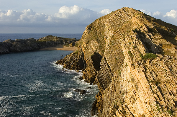
The El Portío cove lies immediately to the west. It is a broad, elliptical cove of approximately 40,000 m², formed by the advance of marine erosion through an extensive breach of around 250 m in the Cenomanian limestone ridge. Here, the dismantling of the pre-existing relief is more advanced than elsewhere along this coastal stretch. Sandy beaches develop along the eastern and western margins, resting on the abrasion platform. Behind the eastern El Portío beach lies one of the most visually striking outcrops in the area, owing to the subvertical dip of the Turonian marly series, combined with differential erosion controlled by the alternation of layers with varying wave resistance and the presence of joint networks with different patterns and dimensions for each layer.
Somocuevas
–
Immediately following the cove is the Somocuevas Peninsula, composed of Aptian limestones, the oldest rocks of the Geosite. These form a set together with the line of islets of the same nature, known as the Urros de Liencres, which extends eastward. The western end is occupied by the depositional complex of the Liencres dunes, shaped by the entry of the Pas River into the Cantabrian Sea. The extensive beach (excluding its extension at Canallave) measures approximately 1,500 m in length, half of which consists of a NE-SW oriented coastal spit. The beach front slope varies along its length: the northeastern end has gentle slopes and is clearly dissipative, whereas the spit end exhibits a markedly reflective character. From the beach, in the direction of the prevailing NW winds, a large and powerful climbing dune rises, ascending the slopes of the nearby Monte Tolío. The system includes a primary dune of variable height between 10 and 15 m, with secondary and tertiary dunes progressively increasing in height towards the SE, alternating with interdunal depressions that, in some areas, form wetlands due to the proximity of the water table.
Access to the Global Geosite
–
The main access points to the Geosite are as follows: at the western edge, take the A67 motorway towards Santander, exit at Boo de Piélagos, then follow the CC231 towards Liencres, entering through the Las Dunas de Liencres Natural Park and the Costa Quebrada Geopark.
From the eastern end, follow the S20 from Santander towards Torrelavega, exit at Corbán, and continue along the CC231 towards Soto de La Marina, where signs direct you to the Covachos and La Arnía beaches.
Internal accessibility within the Geosite is good, with most points of interest reachable via paths and roads, and some sections of the coastline walkable on foot. In these areas, it is important to respect private estates and properties, and to avoid crossing privately owned meadows. When undertaking routes, visitors must not remove plants or disturb local wildlife or livestock. Dogs must be kept under control in accordance with the regulations of each area.