
The Geopark
–
–
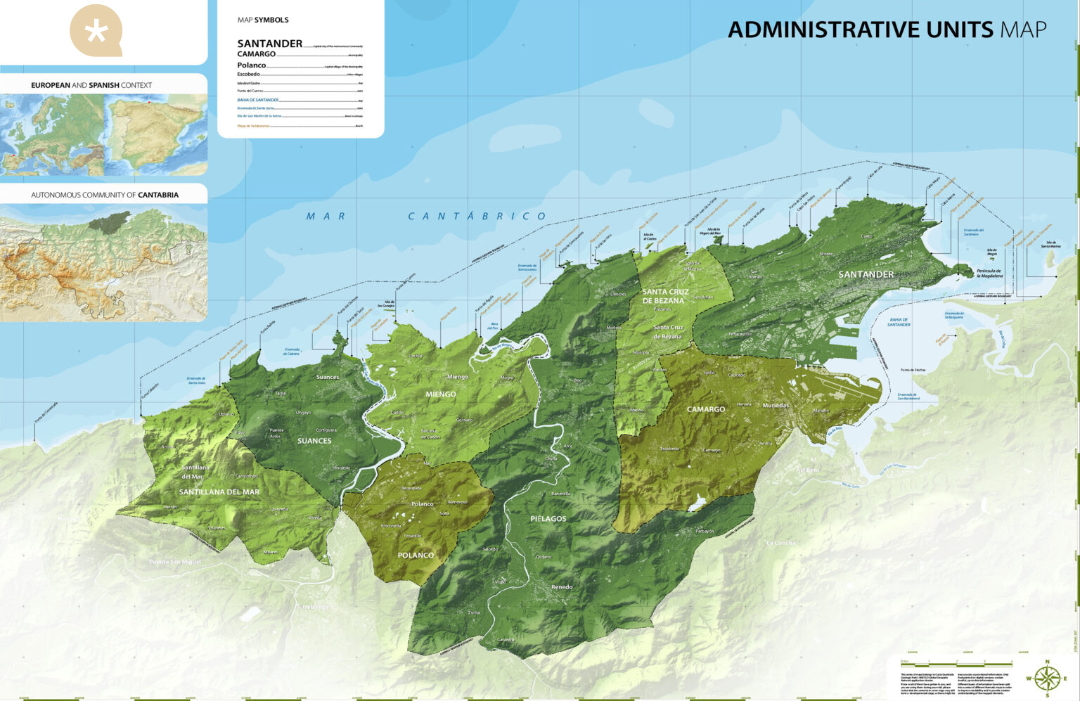
Located between Santander Bay and Punta del Pollo (Punta Calderón), in the municipality of Santillana del Mar, and encompassing eight municipalities (Santander, Camargo, Santa Cruz de Bezana, Piélagos, Miengo, Polanco, Suances and Santillana del Mar), the geopark is not only an extraordinarily attractive area, but also a unique showcase of coastal landforms. Here, visitors have the opportunity to witness geology in action and to discover, in a direct and accessible way, the origin and evolution of our planet.
This geological story can be understood through outstanding examples found along coastal paths and inland routes. Simply observing these striking features leads visitors—even those unfamiliar with Earth sciences—to the same ideas and conclusions reached by early geologists. Geology here is truly for everyone.
The Costa Quebrada Geopark covers 345 square kilometres of coastal plains, hills and river valleys, each with its own distinct geological character. Of this total area, 270 square kilometres are terrestrial, while the remaining 75 correspond to the surrounding marine environment.
The relentless interaction between tilted rock layers and marine processes has created a remarkably diverse array of structures and landforms along nearly 20 kilometres of coastline. Cliffs, arches, sea stacks, coves, beaches, tombolos, dunes, spits and estuaries vividly illustrate the constant and inexorable evolution of coastal landscapes. A closer look at the rock outcrops reveals the remains of ancient tropical reefs, extensive beaches and forests, marine ecosystems frozen in time, and the catastrophic events that led to their disappearance. The geopark also highlights the close relationship between human societies and geological heritage throughout history.
–
Following its recent designation as a UNESCO Global Geopark, Costa Quebrada has unveiled a new visual identity. This new brand is a reinterpretation of the former logo—created when the territory was still a candidate—retaining the letter “Q” as its central element. Previously, the “Q” incorporated the silhouette of a Micraster, a fossil sea urchin characteristic of the Portío and Cerrias area. The new design adopts a more abstract and streamlined graphic language, aligned with international standards of visual communication.
Around this “Q”, a graphic system has been developed whose elements, when brought together, evoke a line of urros (rock pinnacles) and subtly read as “Costa Quebrada”, the evocative name coined by Jesús Mojas to define such a singular landscape. Rather than offering a literal representation, the new brand invites personal interpretation, reflecting the richness, diversity and complexity of a territory with an increasingly global presence—one whose value calls for a firm commitment to conservation.
–
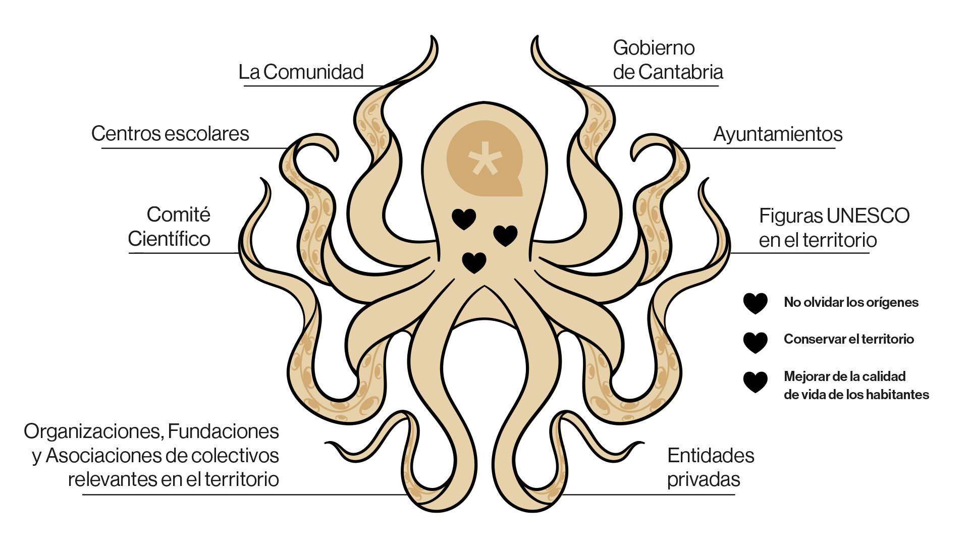
The geopark is a civil society initiative promoted by the Costa Quebrada Association, aimed at providing this valuable territory with a respectful and sustainable strategy for socio-economic and cultural development.
This approach seeks to enhance the area’s exceptional landscape and geological resources, fostering emotional and economic ties between local communities and their territory, while ensuring its conservation and transmission as a shared legacy.
To achieve this goal, the geopark follows a progressive implementation plan, through which facilities and services are gradually established and improved year after year. Each strategic step is carefully assessed, involving public authorities, local stakeholders and citizens in a collective effort of growth and continuous improvement.
The heart of Costa Quebrada represents a spectacular synthesis of coastal dynamics. Along its coastline, visitors can observe an almost complete catalogue of erosional and depositional coastal landforms: marshes, reflective and dissipative beaches, tombolos and dune fields coexist with cliffs, headlands, coves, isthmuses, islets, sea stacks, abrasion platforms, raised marine terraces, blowholes and hanging valleys.
Most importantly, this impressive array of landforms allows us to reconstruct the erosional history of a retreating coastline, visualise its past appearance, and anticipate its future evolution. The area exhibits different patterns and phases of coastal retreat, controlled by geological structure and the alternation of materials with varying resistance to marine erosion.
For these reasons, the stretch between San Juan de La Canal and the Miengo Marsh has been included in the Global Geosites Catalogue—which brings together the most significant geological sites worldwide—under the designation Liencres Dunes and Costa Quebrada Coastline (code CB-010).
Beyond their geomorphological value, the coastal outcrops reveal a rich stratigraphic and palaeontological heritage, enabling the study of the origins and environments in which the rocks, now sculpted by the waves, were formed.
They preserve the evidence required to reconstruct the major events of the last 125 million years in this corner of the planet: continental collisions, mountain building, sea-level changes, stable periods, climatic shifts and biological extinctions—all permanently recorded in stone.
Costa Quebrada is a privileged territory hosting some of the most significant and well-known manifestations of European prehistory, while also serving as the stage for key historical episodes in Cantabria.
The presence of several human species during the Paleolithic has left one of the richest and most important collections of artefacts and artistic expressions in the world. From Mousterian handaxes associated with *Homo neanderthalensis* to the simple Asturian picks of the Epipaleolithic, and including portable art and the world-famous Magdalenian cave paintings and engravings, the territory allows visitors to immerse themselves in the context of early human settlement in Europe and to explore the worldviews and daily lives of its first inhabitants.
The Metal Ages also left their mark, particularly during the Iron Age, when the Romanisation of the pre-Roman Cantabrians took place. Sheltered in fortified hillforts during periods of conflict, they bequeathed monumental discoidal stelae, which today form a powerful symbol of Cantabrian identity.
Numerous medieval remains can also be found throughout the area, including distinctive Visigothic burials and a dense network of military, religious and civil buildings linked to the origins of the Asturias de Santillana and the noble conflicts that shaped the foundations of modern Cantabria.
In the Modern Age, the demand for timber for nearby cannon foundries radically transformed the landscape, triggering deforestation processes that continue to this day. Simultaneously, the liberalisation of trade with the Americas led to the development, in municipalities near the Port of Santander, of one of the highest concentrations of river and tidal mills in Europe.
More recent history has also left its mark on Costa Quebrada. The network of trenches, bunkers and machine-gun nests scattered along the coastline—particularly prominent in the Tolío massif—testifies to the strategic importance of this territory during the Spanish Civil War.

Actividades y reservas: (+34) 604 455 946
Área de Educación: (+34) 681 628 884
Horario de atención: 9:30-17:00h.